
See the Tri-State Marker and be in three states at once! The meeting point of Kansas, Oklahoma, and Missouri is 6 miles east of Baxter Springs on Highway 166/400. Turn south on the small paved road just west of the state line, and continue to the dead end. Built in 1938
Baxter Springs, KS Geographical MarkersRiverside Park is located at the east edge of Baxter Springs on Spring River on the south side of Highway 166
Baxter Springs, KS RecreationThe soldier's plot in this cemetery was designated by the federal government after the Civil War on ground donated by the city for that purpose. It is under the jurisdiction of the National Cemetery Plot in Ft. Scott. The soldier's monument was erected in the spring of 1870
Baxter Springs, KS CemeteriesTake the self-guided Civil War tour of Baxter Springs. Visit 12 points of interest relating to the attack on Ft. Blair and the subsequent Battle of Baxter Springs. For example, SITE #2
Baxter Springs, KS ToursErected by the Baxter Springs Chapter of the DAR in 1931, the marker is dedicated in Memory of Gen. James G. Blunt and his escort who, defenseless fell victims to the inhuman ferocity of guerillas, led by the infamous Quantrill in his raid upon Baxter Springs, October 6, 1863, in which 135
Baxter Springs, KS Historical MarkersCross Timbers State Park encompasses 1,075 acres including five recreation areas surrounding Toronto Reservoir which means al...
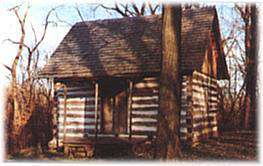 The log cabin was built east of the Lowell Cemetery in the 1870s. R.A. Hibbard built it as a home for his brother-in-law's family. Kent Lynch purchased the property and donated the cabin to the Histor...